2018 Exploration Summary
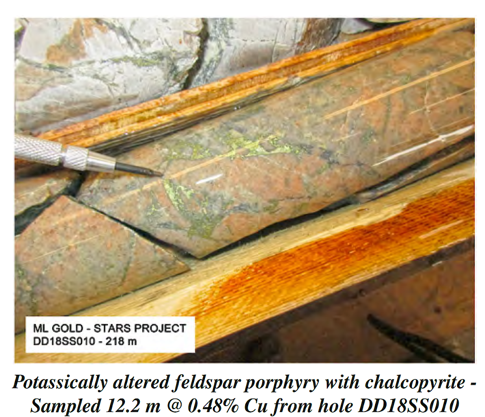
Potassically altered feldspar porphyry with chalcopyrite - Sampled 12.2 m @ 0.48% Cu from hole DD18SS010
During 2018, a total of 8,951 metres of drilling was completed by PEMC and partner ML Gold Corp. ("ML Gold"). PEMC conducted reverse circulation ("RC") drill programs on five of its projects in addition to an airborne geophysical survey on the Moffat Project. ML Gold conducted diamond drilling in addition to geophysical surveys at the Stars Project.
PEMC completed 2,479 metres of RC drilling in 41 holes. The decision by PEMC to purchase its own custom-built RC drill rig and to operate the rig with PEMC’s own dedicated crew was in response to evolving conditions within the junior mining sector. Most importantly, how can we do more with less while recognizing that discoveries are made by drilling? Purchasing and operating a drill was a bold step for PEMC and was not without challenges. As anticipated the primary challenge was overburden of various thicknesses. By the end of the season the Company was consistently able to overcome overburden challenges. Our initial RC drill program at the Red Project averaged 46 metres per hole with holes ranging in depth from 11 to 94.5 metres. Average hole depth at the Wildcat Project was 48 metres and for the holes drilled at the Kitimat the average depth of holes was 60 metres. For the first three drill programs of 2018 PEMC used a 400 cfm / 200 psi compressor that the company rented. PEMC made the decision to purchase a custom built compressor system rated at 660 cfm / 350 psi. The compressor system consists of 2 modular compressors and a booster unit.
Due to the modular nature of this setup it is highly mobile and if necessary suitable for helicopter supported program. The results were immediate. The next drill program at the Copper King was helicopter supported and averaged 114 metres per hole. Although the drill program at the Moffat averaged 55 metres per hole the decision to keep the holes short was based on information from drilling. The final drill program was a phase 2 RC drill program at the Red Project. Again, there were significant improvements in production and PEMC was successful in completing a 102 metre hole in one shift while averaging 104 metres per hole. This increased production translated into significantly reduced drill costs on a cost per metre basis.
PEMC also began testing a passive seismometer to determine if it was possible to get an indication of depth to bedrock prior to drilling. In areas where PEMC intended to drill we were successful in determining depth to bedrock and therefore eliminating drill holes that would not reach bedrock. For PEMC this technology was a game changer. Knowing the depth to bedrock has several advantages. Firstly, whether or not to drill at a certain location. Secondly, depending on depth to bedrock PEMC is able to configure the drill with the appropriate tooling best suited for the situation. By the end of the season PEMC was consistently able to drill 80-100 metres per day at a cost of approximately $2,500 day (not including mobilization and demobilization costs). From the perspective of exploration success during 2018, of the six projects drilled by PEMC and partner ML Gold, two returned positive results, encountering encouraging copper values in drilling. PEMC management is confident that significant increases in drilling efficiency and production will be attainable during 2019 and that it will be an exciting year for the Company and shareholders.
2019 Corporate Outlook
Over the next several months PEMC will continue to evaluate opportunities to acquire additional exploration projects either through staking or through option agreements with third parties. With the recent acquisition of the Paragon and Sat projects in the Babine Copper-Gold porphyry district PEMC now holds over 170 square kilometres as part of its Bulkley Initiative. Importantly, the area is well suited for the development of bulk tonnage copper-gold deposits. PEMC is actively pursuing opportunities with potential partners to advance projects and the large land position represented by the Bulkley Initiative is well suited for potential partners.
2018 Partner Funded Drilling at Stars Project
During 2018, ML Gold Corp. completed a total of 6,472 metres of diamond drilling in 16 holes in addition to a property wide airborne magnetic survey. Diamond drilling during 2018 focused on the Tana Zone which is located on the eastern flank of the 5-kilometre-long ovate magnetic anomaly centered within the property.
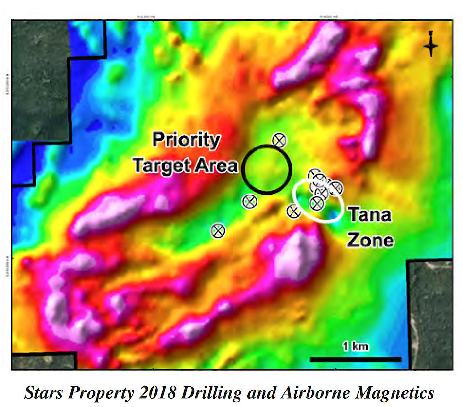
Stars Property 2018 Drilling and Airborne Magnetics
Copper mineralization was encountered in numerous drill holes and has been directly related to feldspar porphyry intrusions with zones of increased potassic alteration typically making up the central portions of the mineralized intervals. Recently released assays from holes 11, 12 and 13 again continued to intersect vein-hosted and disseminated copper mineralization. Additional assays from holes 14, 15 and 16 (DDSS18014-016) are currently being processed. Highlights from recent drilling include:
• Hole 11, located on the eastern extension of the Tana Zone, intersected two separate mineralized intervals (91 metres @ 0.25% CuEq from 75.29 to 166.73 metres; and 106 metres @ 0.22% CuEq from 218.54 to 325.22 metres)
• Hole 12 intersected two separate intervals of copper mineralization (21 metres @ 0.17% CuEq from 47.85 to 69.19 metres; and 40 metres @ 0.19% CuEq from 105.77 to 145.39 metres)
• Hole 13 intersected a large interval of copper mineralization with numerous higher grade sub-intervals (73 metres @ 0.30% CuEq from 54.25 to 127.41 metres; within 183 metres @ 0.25% CuEq from 8.53 to 191.41
metres)
• All three holes intersected copper mineralization associated with a network of porphyry intrusions
• Mineralization at the Tana Zone comes to surface and remains open along strike and to depth
The Stars Property is ideally located 40 km southwest of the resource town of Houston, B.C. The project site is lowelevation, gentle topography, and is accessible by all-season main line resource roads making it ideal for low-cost open-pit mine development. Recent Property Acquisitions Bulkley Initiative The most significant deposits and occurrences in the Babine Lake area are temporally and spatially related to Eocene (50 Ma) Babine intrusions. These host more than a dozen deposits and occurrences in addition to the past producing Bell and Granisle open-pit mines which processed 130 million tonnes with average recovered grades of 0.40% copper and 0.15% gold between 1966 and 1992. Babine intrusions occur as small stocks, plugs and dike swarms emplaced along northwest-trending regional faults developed in arc-derived Mesozoic volcanic and sedimentary assemblages. The dominant host rock for copper-gold mineralization is a distinctive, fine- to medium-grained, crowded biotite feldspar porphyry (BFP) of granodiorite composition. Copper-gold mineralization occurs as chalcopyrite and bornite within narrow quartz-filled fractures and stockworks and as disseminations within and marginal to BFP intrusions. Although most of the known porphyry deposits and occurrences were found by basic prospecting and stream sediment geochemistry, subsequent exploration in the Babine area has been hampered by extensive glacial overburden cover.
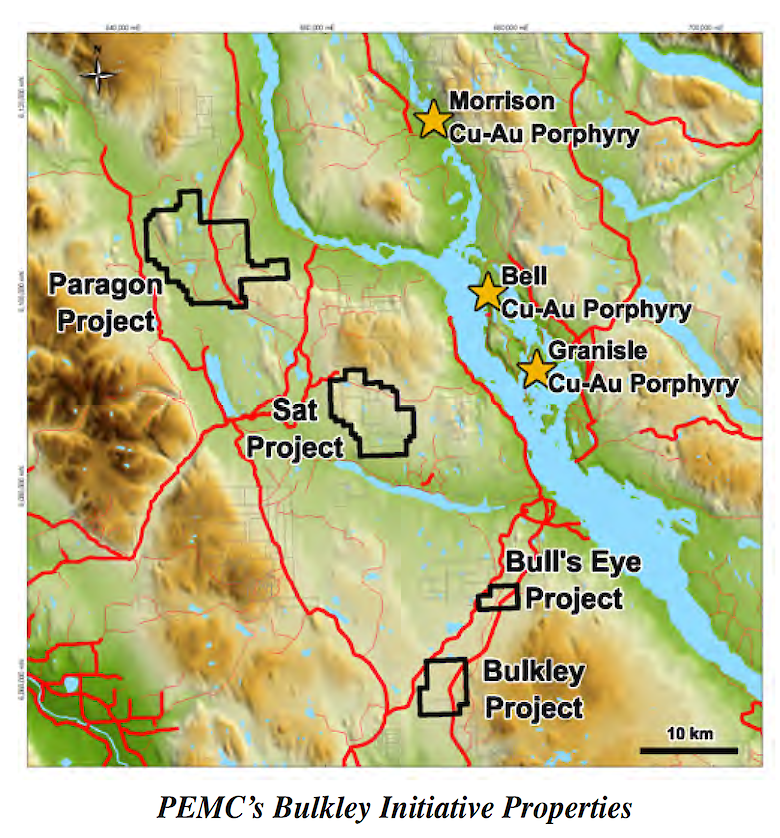
PEMC’s Bulkley Initiative Properties
Paragon Project
The Paragon Project is a consolidated 9,099 hectare land position in the Babine Copper-Gold Porphyry district in central British Columbia. The amalgamated Paragon Project combines the Company’s Wasp Property, the recently optioned Nilkitkwa Property and prospective ground staked by the Company. The Paragon Project covers four copper-gold prospects within 30 km of three copper-gold porphyry deposits, including the past-producing Bell and Granisle Mines and the advanced Morrison copper-gold porphyry deposit. These deposits are genetically and spatially associated with Biotite Feldspar Porphyry (BFP) dikes. PEMC is targeting analogous geology at the various prospects situated within the Paragon Property boundary. Results from due diligence rock sampling program at the Nilkitkwa Property are summarized below.
The four copper +/- gold prospects consist of the Rebinsky, HOL, Wasp and Big Joe prospects. The Rebinsky prospects, which are the focus of the ground within an option agreement, cover multiple sulphide showings that were recently uncovered during ongoing logging activities. In the northern portion of the Nilkitkwa Property, extensive quartz-sericite-pyrite +/- magnetite alteration exists proximal to a covered magnetic anomaly. In the southern portion of the property, copper mineralization is found in a recently exposed rock quarry where it consists of localized chalcocite coating chalcopyrite and pyrite grains which are disseminated and filling fractures in chloritecarbonate altered andesitic volcanics. At the HOL prospect, a 1,500 m x 600 m coppermolybdenum soil anomaly is coincident with a strong IP chargeability anomaly immediately adjacent to a major northwest trending fault. Historical drilling at the southeastern margin of this area encountered copper mineralization associated with BFP dikes, though assay results were not reported. Historical drilling at the Wasp prospect encountered anomalous copper as disseminated and fracture filling pyrite-chalcopyrite associated with BFP dikes. The Big Joe prospect consists of two historical trenches over 1 km apart where copper as chalcopyrite +/- bornite was encountered and found to be associated with northwest trending structures. The Paragon Project is ideally suited for PEMCs reverse circulation drill and the Company will be developing and refining targets for intended drill testing in 2019.
SAT Project
The Sat property consists of 13 mineral claims covering 5,040 hectares in Central British Columbia. The property is located approximately 15 kilometres to the southeast of PEMC’s Paragon Project and lies within the Babine Copper-Gold Porphyry district. PEMC entered into an option agreement to acquire a 100% interest in 10 mineral claims representing the core of the Sat property by making staged cash and share payments of $65,000 and 500,000 shares over a four-year period. Three additional mineral claims were staked by PEMC to cover geophysical targets that will be evaluated over the coming months. Historical work conducted on the Sat Property includes over 3,000 metres of diamond drilling, 180 line-km of induced polarization surveys, collection of over 3,500 soil geochemical samples and ground and airborne geophysics. Historical drilling focused on was has been interpreted as a pyrite halo, measuring approximately 1,200 x 600 metres. Drilling encountered biotite-feldspar porphyry dikes and sills which intrude moderately to intensely chlorite-epidote-calcite altered andesitic volcanics, argillite and basalt. Anomalous copper values are present in several holes, though intercepts indicating a potentially economic deposit have not been encountered to date. Thorough data compilation and review has outlined several target areas untested by drilling, the most significant of which is situated adjacent to the interpreted pyrite halo where bedrock exposures are obscured by glacial overburden. A network of logging roads make the Property ideally suited for PEMCs reverse circulation drill.
Exploration 101 - Passive Seismic Bedrock Mapping
PEMC is constantly looking for new strategies and technologies that have the potential to assist with mineral exploration. During 2018, PEMC began testing a passive seismometer to evaluate this relatively new technology’s ability to provide subsurface information prior to drilling. A seismic sensor models H/V (horizontal/vertical) curves to obtain shear wave velocity profiles (Vs) which allows for imaging of the subsoil. This instrument has the potential to greatly increase efficiency and productivity when reverse circulation drilling.
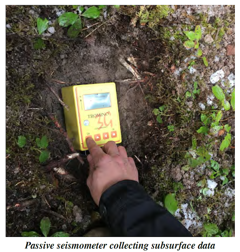
Passive seismometer collecting subsurface data If the depth to bedrock is known the drill crew is able to configure the drill with the appropriate casing advancing system that is best suited for the depth of the overburden. Most importantly, if the depth to bedrock is beyond the capability of the drill the decision can be made to move to another location and avoid unnecessarily drilling holes that do not have a chance of reaching bedrock. At the location of a proposed drill hole a small hole is excavated in the ground and the unit is placed in the hole for a period of 20 minutes while passive seismic readings are collected. Following this, the data is transferred to a computer where specialized software is used to plot a profile of the subsurface. The resulting colour plot can be used to determine the depth to bedrock and in some cases clay horizons within the subsoil profile. Additionally, data obtained from the passive seismometer may assist with geophysical interpretations, specifically induced polarization surveys.

PEMC intends to reinterpret geophysical data previously collected on a number of selected projects during 2019 and evaluate the potential to augment future induced polarization inversions with seismic data. This tool is now an essential component of our exploration programs as it will help us avoid drilling unknown thicknesses of overburden.